Hike around Glashütte
Walddorfer Straße – Kühnerinsträßle – Redwood Trees – Glashütte – Waldenbuch
- Distance: 10 km
- Walking time: 3 hrs
- Elevation gain: 140 m
The starting point for our hike is the hiking information board at the bus stop "Postamt Waldenbuch", where we can trace the route we are to take. After crossing the road at the pedestrian crossing we take the bridge over the Aich. This short stretch leads into the road Auf dem Graben. We follow it to the right and bear left at the next junction into Neuer Weg. Continue along this road to the Tithe Barn (Zehntscheuer), built in the 16th century (note the high-water marks on the bottom right-hand corner), to where Walddorfer Straße branches off to the right. We follow it uphill and go straight ahead at the junction with Bonholzstraße, along the asphalt farm road towards the edge of the forest. We pass a horse farm on the left and two T-shaped, abutting barns. Immediately after these, we turn left up the forestry road (Kühnerinsträßle), through sparse deciduous forest, for about 1.9 km. We cross the hiking trail with the blue dot sign, and later also the trail with the red cross. We carry straight on along the broad, slightly uphill track, which ends on the crest of the Betzenberg hill (494 m) at a junction where five trails converge like the spokes of a wheel. The barbeque area is an ideal place for a break. Then we go left along Dettenhäuser Sträßchen and continue gently downhill, following the blue U hiking sign.
Detour:
After c. 1.2 km a path branches off on the right for about 30 m to a forest cabin. The memorial plaque over the door tells us that it was built "In memory of the forest ranger Erwin Knödler – forester and gamekeeper 1923 - 1955". We have reached the "Weißes Häusle" (white hut), where we find another barbeque site and behind it three redwood trees of an impressive height, growing side by side,.
Redwood = Sequoidendron giganteum. Schönbuch's sequoias were grown from seeds which came from America. King Wilhelm I of Württemberg had them sown in the Wilhelma (Stuttgart's zoological and botanical gardens). The young saplings were distributed to the Kingdom of Württemberg's foresters and planted in the forest.
Returning to our path, we continue to follow the blue U until we come to two forks within a short distance of each other. Our path is always the one leading downhill to the left. At the second fork, we have the option of another short detour.
Detour:
Roman remains at the Stellenbrünnele (well)
We take the right-hand trail (on the left there's a forest information trail) and go straight ahead for c. 300 m. On the left, some steps with a railing lead suddenly downwards. This path takes you after c. 60 m to the Stellenbrünnele, whose spring was harnessed in 1905. Here we find the casts of four fragments of Roman burial monuments and cult objects, which were discovered here in 1869 while a seed nursery was being laid out. A detailed description is provided on the 3 large information boards. Having studied these, we retrace our steps back to the trail and to the fork with the hiking sign of the blue U.
As mentioned previously, our signposted route now leads more steeply downwards. We come to an information board "The History of Schönbuch" on the forest information trail, and later a board showing our native woodland birds. Further down, a forestry path joins the trail from the right, with a sign on a tree saying Stellenbronnenweg. Our route continues downwards, but we can decide at this point whether to make another short detour:

Detour:
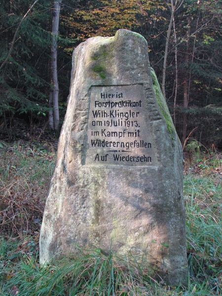
On the left, the forestry commission erected a plaque in 2011 pointing to a minor monument, not visible from the main path, which commemorates the murder of a trainee forester. We follow the path diagonally some 20 m into the forest, where a mossy, roughly-hewn, man-high (180 cm x 110 cm x 60 cm) pillar of sandstone stands. This memorial stone bears the inscription: "On this spot the trainee forester Wilh. Klingler died in the fight against poachers on 19th July 1913 -- Auf Wiedersehn."
We retrace our steps to the main trail and continue our hike for another short downhill stretch. A large left-hand bend is followed by an almost 90-degree right-hand one. At this point we leave the signposted hiking trail and take the rarely-used road into the allotment plots. We follow the slightly uphill curve until we reach a T-junction, where we take the right-hand fork. After a short way the asphalt road begins, taking us slightly to the right and downhill, until we reach the first houses of the community of Glashütte.
Along Wacholderweg we reach the centre of Glashütte (c. 720 inhabitants) and the square named after "Poor Conrad" (Peasants' Uprising), with its bus stop and fountain. At the next crossroads we turn left into Brunnenstraße for a short way, turning right almost immediately into Rübezahlweg and continuing uphill until we come to the house No. 18. Now we have an almost straight road to Waldenbuch, with a lovely view down into the Aich Valley and over to the opposite ridge with the districts of Liebenau and Kalkofen (high-rise buildings). Our road leads into Tieräckerweg, which is joined by Schloßgartenstraße. This in turn takes us into Bahnhofstraße, which we follow to the left. On the right-hand corner is the "Sonnenhof" residential complex for the elderly, which we pass. Now we go along Vordere Seestraße and turn into the road called Auf dem Graben, reaching our point of departure.
This hike was devised by Walter Nogger (a guide with the Schwäbischer Albverein e.V., Waldenbuch branch.
Recommended hiking map
Topographic map "Stuttgart“, page 12, scale 1:35.000, published by: Landesamt für Geoinformationen.
